ROUTES
LETTERS
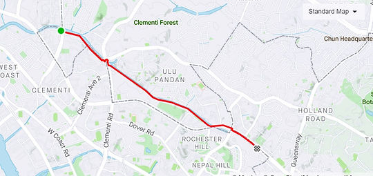
Ignite
Start our event off right with this short one-way track through nature!
Length: 2.01 km
Difficulty: Easy
Location: Rail Corridor (Bukit Timah)
Type: Run/Walk

IgNite
Length: 8.41 km
Difficulty: Medium
Location: Mount Sinai
Type: Run/Walk
Ignite
Length: 2.01 km
Difficulty: Easy
Location: Rail Corridor (Bukit Timah)
Type: Run/Walk
IGnite
Length: 4.71 km
Difficulty: Easy
Location: Woodlands (Bukit Timah)
Type: Run/Walk

Ignite
Length: 2.01 km
Difficulty: Easy
Location: Rail Corridor (Bukit Timah)
Type: Run/Walk
IGnite
This route is for our Northies, an easy stroll through the neighbourhood.
Length: 4.68 km
Difficulty: Easy
Location: Woodlands
Type: Run/Walk
IgNite
For a slightly more challenging yet enjoyable run, here’s an excellent route through Mt Sinai.
Length: 8.41 km
Difficulty: Medium
Location: Mt Sinai
Type: Run/Walk

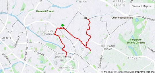
IgnIte
Here’s another long linear path to enjoy beside the canal through Dover.
Length: 4.35 km
Difficulty: Easy
Location: Dover
Type: Run/Walk
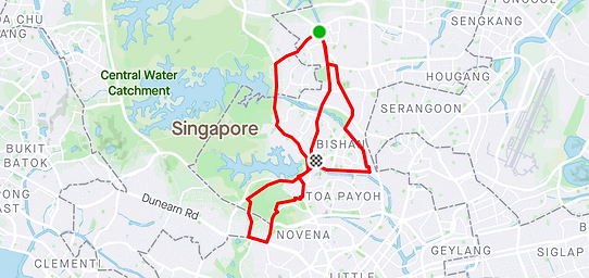
IgniTe
This route is available for any kind of activity you choose! From running, walking, to cycling.
Length: 7.54 km
Difficulty: Medium
Location: Bishan
Type: Run/Walk/Cycle

IgnitE
For a slightly harder walk or hike, try this route which ends at the main sporting hub of Singapore to explore Kallang!
Length: 16.5 km
Difficulty: Hard
Location: Kallang PCN
Type: Walk/Hike

SHAPES
House
The first of our fun shape-related routes, start off with this exciting route from Mandai to get you hyped for the rest of the days ahead!
Length: 3.88 km
Difficulty: Easy
Location: Mandai
Type: Run/Walk

Heart
Revolving around historical sites like Fort Canning Park and Clarke Quay, this route not only shows you the heart of where Singapore started but also the heart we have for our beneficiaries.
Length: 4.92 km
Difficulty: Easy
Location: Fort Canning
Type: Run/Walk

Kidney Bean
This easier route is great for those who just want a short warm-up session in the Ang Mo Kio Gardens. And maybe will get you craving some kidney beans too…?
Length: 0.75 km
Difficulty: Easy
Location: Ang Mo Kio
Type: Run/Walk

Christmas Stocking
Length: 3.5 km
Difficulty: Easy
Location: Yio Chu Kang
Type: Run/Walk

Facing Up Snail
Length: 6.69 km
Difficulty: Medium
Location: Bukit Batok
Type: Run/Walk

Fire
We hope that this route through the northeast of Singapore will ignite the fire in you and help you power through the other routes!
Length: 32.5 km
Difficulty: Medium/Hard
Location: Hougang/Serangoon
Type: Cycle

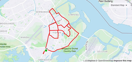
Flower
Our flower route will take you through the area of Yishun and the heartlands of our garden city.
Length: 18.64 km
Difficulty: Hard
Location: Toa Payoh
Type: Cycle

Turtle
Length: 19.21 km
Difficulty: Hard
Location: Toa Payoh
Type: Cycle

OTHER ROUTES
Botanics
This leisurely run through our very own UNESCO site will transport you into a world of flora and fauna, perfect for friends to enjoy!
Length: 1.88 km
Difficulty: Easy
Location: Botanics
Type: Run/Walk

Sentosa
Length: 19.77 km
Difficulty: Easy
Location: Sentosa
Type: Cycle

Marina Bay - ECP
This route will bring you on a sight-seeing tour through the city center while enjoying the sea breeze!
Length: 23.53 km
Difficulty: Easy/Medium
Location: Marina Bay - ECP
Type: Cycle

Yishun
Length: 0.75 km
Difficulty: Easy
Location: Ang Mo Kio
Type: Run/Walk
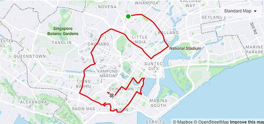
Chinatown - Little India
Also known as “Racial Harmony”. Have a historical cycle through the heart of Singapore and take in the different sights and sounds of our many cultures!
Length: 20.39 km
Difficulty: Medium
Location: Chinatown, Kampong Glam, Little India
Type: Cycle
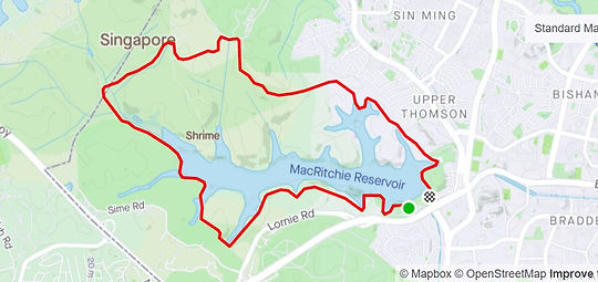
MacRitchie
This one is for the experienced runners or hikers that want to challenge themselves on a longer run around the Macritchie reservoir!
Length: 10.17 km
Difficulty: Hard
Location: MacRitchie
Type: Run/Hike
Lentor - Upper Thompson
This long loop through the Ang Mo Kio park connector gives you a chance to appreciate running alongside the Kallang river.
Length: 8.65 km
Difficulty: Hard
Location: Lentor, Upper Thompson
Type: Run/Walk

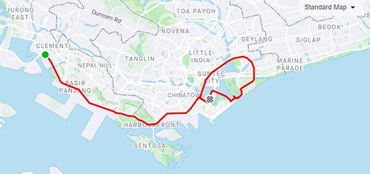
West Coast - Nicoll Highway
From the East to the West, this cycle is perfect for exploring the entire length of the southern coast of Singapore.
Length: 26.78 km
Difficulty: Hard
Location: West Coast, Telok Blangah, Nicoll Highway
Type: Cycle
West Coast - Bishan
Our most challenging cycling route, this one will lead you through various sights of Singapore, from the scenic coastal views, to the heartlands.
Length: 48.35 km
Difficulty: Hard
Location: West Coast, Bishan
Type: Cycle

West Coast - East Coast
Length: 29.35 km
Difficulty: Hard
Location: West Coast, East Coast
Type: Cycle

Upper Thompson + Bishan + Ang Mo Kio
One of our longer cycling routes, this cycle will bring you through one of your best journeys through central Singapore.
Length: 27.93 km
Difficulty: Hard
Location: Upper Thompson, Bishan, Ang Mo Kio
Type: Cycle